A circular walk in 15 parts
I have just spent far too long dividing the 205 miles into comfortable 25 km segments. You would think that this would be easy enough given that I possess a guide book that describes the whole route in great detail. Apart from the length of the walk I have very few restrictions, I would prefer to finish the walks in a pub rather than in the middle of a field, and a nearby railway station would be handy – but I am of an age that warrants a bus pass, so I have choices.
I quite like maps and, of course, the Ordnance Survey map accurately represents a world without weather. I also quite like my Garmin handheld GPS thing (it’s an Oregon 450 for those who need to know the details) because it has ALL the Ordnance Survey maps (1:50 000 scale) for the whole of the country and it fits in my pocket and works in the wind and rain. The GPS thing would be a miracle if all it was was a kind of Kindle for Cartography, but of course it’s much more than that. Fortunately there is no little voice telling you to ‘turn around when possible’ but it will tell me about Sunrise and Sunset – not that I ever ask. Unfortunately, I do have to tell my GPS thing where I want to go, using Garmin’s own software – it’s called BaseCamp and it’s a nightmare for so many reasons. I’ve never been able to figure out the significant difference between a ‘Track’ and a ‘Route’ let alone a ‘Trip’ or (lately) an ‘Adventure’. I quickly got the hang of creating ‘waypoints’ and then linking them together so that when they were ‘sent to the device’ (downloaded) I knew how far to walk and in which direction – even if lost, although the idea was not to get lost in the first place – I’m not new to SatNav or Marine Chart Plotters. BaseCamp allows me to choose from a variety of ‘Activities’ but then goes on to differentiate between ‘Bicycling’ and ‘Tour Cycling’ also it has ‘Walking’ and ‘Hiking’ for a long time I couldn’t get any of them to work – I was forced to use the activity known as ‘Direct’ which then couldn’t work out how long a walk would take. I then discovered that although I had ALL the OS maps, none of them were ‘routable’. Luckily, I then discovered that I could download routable (and open-source) maps from Open Street Map so now I can plan a walk (route/track/trip/adventure) and get BaseCamp to predict the arrival times, well I could if the software could plan a sensible route through my dotted lines (points/shaping points/waypoints) – it can’t, and here is an example of it’s stupidity.
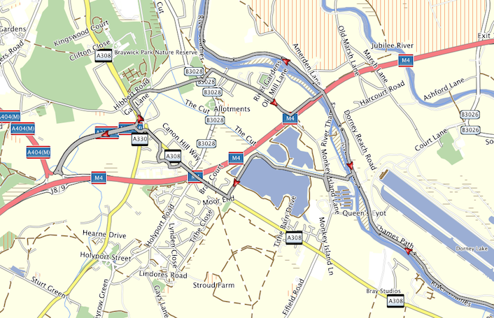
This is part of the first walk, along the Thames Path, but for no reason at all BaseCamp decides to turn back on itself (close to Dorney Reach Road) and takes me for a 5 km detour.
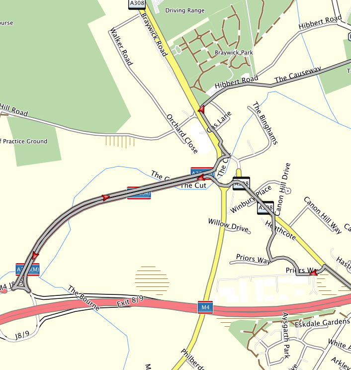
This detour isn’t even credible. Note how when ‘walking’ along a straight road it wanders off up Priors Way and when ‘walking’ across a roundabout it turns left, to another roundabout and then turns right just to come back on itself.

Finally, what sort of map interface has an icon for a Ghost Town but nothing for a Railway Station
In Summary
The walk has virtually started